Behold The Fetch

If you are currently residing in Cape Town, you cannot have failed to notice the somewhat extreme meteorological conditions that are prevailing this morning. The rain – and there’s a lot of rain – is travelling horizontally past our windows, assisted in no small part by the ridiculously strong and blustery northwester. It’s dark, it’s grey – dark grey – and it’s cold. Cold, dark grey.

Winter. She is here.

But where did this remarkable weather come from, I hear you ask. Well, here’s your answer: :

This was the situation at midnight last night. Now, ten hours later, Cape Town (central, “helpfully” indicated by a tiny red dot) has slipped underneath that pointy line indicating a phat cold front, linked to those double-barrel low pressure centres. And that’s why we’re getting what we’re getting right now.

But, while windguru is predicting swells of up to 7 metres for the Cape coast this weekend (and that lengthy fetch shows you why), any avid surfers will probably be disappointed, as Spike from wavescape indicates:

Gather yer nuggets Wednesday as rising 12ft beasts smack thy chops stukkend. Dik SSW surf swells in glassy sea > light NW. Epic. FB 3′ early, 4-5′ in arvi. Cooks.Thursday neargale NW smelts 10′ mess, FB 4′ in stiff offshores. By lunch, strong SW thro. DIK RAIN drench from 8am. Friday heaving 5-10′ storm sea, ragged SW winds > S. Heavy squalls subside a bit. C-c-cold. FB ragged side going onshore. Saturday heaving 5-10′ storm junk in strong S > SSE. FB kak. Sunday lekker calm, leftover 3-5′ S swell. FB fun 3′.

Thanks for that, Spike. Lucid as ever. Consider my chops smacked stukkend.

The forecast for the weekend does suggest that things will calm down a little, although if you were expecting a hefty tan by Monday morning, you may be barking up the wrong country.

Me? I’ll be heading down to Cape Agulhas, where those mad swells will hopefully bring some mad photo opportunities.
And yes, I’ll be taking my thermals along with me…

Is summer finally coming?

As proven by this weather forecast for Cape Town for the week ahead?

Things are looking up. It’s a good sign when even the cloudy days are warm. And I have it on good authority that we may be in for a 29°C scorcha!™ on Sunday. Bring forth my ceremonial braai tongs and slaughter that bloody sheep, Jennifer. Then make a salad.

Meanwhile, less good but far more spectacular weather for my parents in the Isle of Man as a particularly virulent area of low pressure rolled in across the Irish Sea:

This was taken by my Dad this morning in Port St Mary and has a distinctly Kalk Bay feel to it. A quick look at the latest weather report from the local airport suggests that the pressure is still falling there – not good news when you have a three-hour long boat crossing of that sea tomorrow like they do.

Bon voyage…

Strep & Storm

It would appear that Streptococcus has swept through our house like a sweepy thing, leaving behind it a trail of doctor’s bills and expensive antibiotics. How can something so small cost so much?
I mean, I know I have obviously asked that same question about my son (and then my daughter), but this is a damn bacterium!

Based on the fact that this – however unpleasant – is merely an infection with a prokaryotic organism, I brought my laboratory experience into play. In the lab, we have three choices when we want to kill bacteria: extreme heat (132°C, no less), sodium hypochlorite (basically bleach) or alcohol. With that in mind, and not fancying the high pressure steam or the Domestos, I am attacking my vile respiratory tract invaders with a rather decent single malt. It’s like pouring vinegar on a paper cut as it goes past my red raw throat, but I’m pretending not to notice and only thinking of the obvious benefits.
I’m hopeful that it will also aid with a good night’s sleep as well, although other factors come into play on that one. Not least the latest work on my new study. Mindful of the storm front approaching Cape Town this evening, the builders, in their infinite wisdom, decided to try and cover their ongoing work with some large, ill-fitting sheets of plastic nailed across the hastily-installed roof trusses. And that’s why we now have 25m² of flapping heavy-duty plastic right outside our bedroom window.
Bliss.
I’m almost hopeful that it gets taken away by the Northwester early on, although I’m not sure what repercussions that would have on the building work completed so far. Right now, I couldn’t care less. I just want some sleep.

Tomorrow is another day, as they say. Let’s hope it’s a whole lot better than this one was.

P.S. If you see a huge black kite flying across the Southern Suburbs, please drop me an email so that we can come and collect it and any bits of my house which happen to still be attached. Thanks.

Incoming

Cape Town’s first big storm of the year is due this weekend, described on surfers’ website Wavescape as follows:

A moerse storm smacks Cape Town this Saturday with the first of a double frontal burst – the first serious beast of the season… just look at the length of the wind below. Basically it’s a stab wound that bleeds from the ice-shelf right up to your tannie’s koeksusters cooling on her stoep at Stilbaai. It’s the ingrown toenail of a fierce oceanic convulsion, dug out with the scalpel of your childhood veruka, the deepest root canal of all your evils.

Mmmkay.

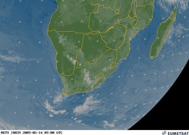
Here’s what Eumetsat shows:

strm1

Which doesn’t look that bad – yet. Further investigation shows that the pressure will dip as low as 940mb though, which is pretty scary, based on the fact that we’re currently sat at 1011mb and Hurricane Katrina was 920mb when it made landfall. (Although not in Cape Town, obviously.)  

I love this sort of weather, even though we’re going to see winds close on 100kph. I hope to get out and about with the camera, like I did last August, which was spectacular.

So assuming we make it through in one piece, what of next week? Wavescape has that covered:

The storm swell is expected to peak at a very steep, short frequency surge to 20 feet by Saturday evening and into Sunday before it boosts to 25 feet on Sunday afternoon, with Monday huge too, Tuesday cranking as the wind eases. The whole coast between Agulhas and the Wild Coast is absolutely off its face on Monday and Tuesday, and solid grinding South swell lasts along the southern Cape all week.

That’s like… totally gnarly, dude.

The Perfect Storm?

It’s Spring Day tomorrow in South Africa. The unofficial start of the good weather that will last through until next July, allowing us to enjoy braais, beers by the pool and some dreadful home performances by the nation’s cricket team. But winter had one last throw of the dice and scored a lucky 7 with a particularly evil cold front which came through on Saturday afternoon. It was pretty nasty, as the SA Weather Service warned us:

Gale force westerly winds (35kt/65km/h) are expected in places over the Western Cape on Saturday. Strong-gale to storm strength winds (in excess of 80km/h) are expected along the Western Cape Coast. Very rough seas with destructive waves in excess of 7m, coinciding with spring high tides, are expected along the Western Cape coast. Heavy falls of rain are expected in places over the western parts of the Western Cape on Saturday. Very cold, wet and windy conditions are expected to set in over the western parts of the Western and Northern Cape Saturday evening. Snowfalls are expected over the western high ground of the Western Cape as well as the south-western high ground of the Northern Cape from Saturday evening into Sunday morning.

Lovely. Thanks for that.
I did pop out on Saturday afternoon, but after almost dying on a tree-lined stretch of road near our house when large chunks of the trees started lining the stretch of road around my car, I declined to go out again.
Until this morning, when a promise of decreasing wind, together with a hint of sunshine and a morbid curiosity to see what was left of Cape Town tempted us down to Mouille Point and Three Anchor Bay.


Stormy scenes at Mouille Point: see more at flickr (and videos too!)

The worrying thing was that these pictures were taken about 4 hours before high tide – and a spring tide at that. I’m due back in Sea Point on Tuesday and I will be very interested to see if it’s actually still there.

Want more pics? Click here.