Your Wednesday Thursday storm briefing

(Following on from your Monday Thursday storm warning and your Tuesday Thursday storm update.)

Hello, Thursday Storm fans (I’m looking at you, UtianG).
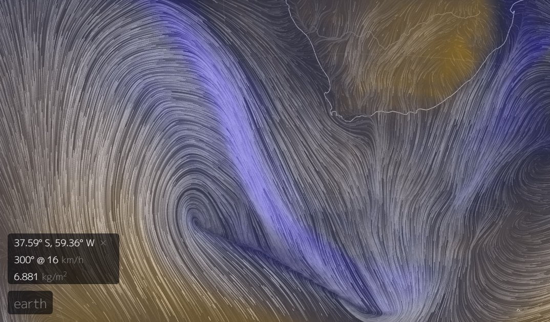
Another day, another lot of isobars.

It’s still coming; it’s still fairly large: there’s been no further relief on the pressure side of things since yesterday’s post. It has been slightly delayed by the traffic from the stop/go system for the roadworks near Tristan da Cunha, and thus we should only expect the worst of the rain late morning tomorrow.

Looking out of my lab window at the cloudless , windless Cape skies this morning, it’s hard to believe that we’re all going to die horribly there’s a cold front just 24 hours away. It’s all so calm and peaceful. And dry.

Here’s the latest synoptic chart, and while we’re all looking at what’s approaching the Western Cape tomorrow, it would be foolish to ignore that second low pressure area behind it which is making its way eastwards across the South Atlantic. At the moment, it looks like that’s going to hit the Cape overnight on Sunday and into Monday, ruining what was already going to be a pretty crappy morning for us all anyway. It’s not going to be as big as tomorrow’s excitement, but it’s a long way off and it does have the potential to change track and give us a proper battering.

But let’s get through tomorrow first, with Windguru predicting almost 40mm of rain over 24 hours for the Mother City, followed by an entirely dark, damp and dreary Friday.

Stay safe, drink red wine, toast a beagle on your log fire and do a crossword. Look after those who don’t have your luxuries: you can donate a bed for 5 nights at The Haven Night Shelter for just R60 without even leaving your chair. Click here and do your bit. I have. Or use Snapscan:

And please share this post (use the buttons below) and get others to do their bit as well.

And then come back for tomorrow’s post entitled:

Damp Squib: What Was All The Fuss About?

or:

Sweet Baby Jesus. We Are Actually All Going To Die!

depending on the prevailing meteorological conditions.

Thursday storm update

Windguru is still shouting about TONNES of rain and 80kph gusts of northwesterly air in Cape Town on Thursday morning, but a quick look at the synoptic charts for the South Atlantic actually indicate that things have calmed down just a little out there [points westsouthwest].

Now, I’m not doubting Windguru. It is, after all, the self-proclaimed guru on these sort of things. But there’s no doubt that the centre of that low pressure area is more diffuse and not as deep as it was yesterday.

If I was a betting man (I’m not), I’d be wondering about whether (no pun intended) this one is not going to pass a little further south than the original forecasts originally forecasted. That would mean that we’d just catch the tail end of the cold front, and that it might not be quite as bad as we were expecting.

I am going to add a couple of provisos here though: firstly, I’m not a professional weather forecaster. Some would say I’m not professional at all, and there are times when I’d find it difficult to argue with them. Secondly, “not quite as bad as we were expecting” is relative, as we were actually expecting it to be really, really bad. So even if I’m right, it might still be really bad.

Of course, the closer the actual event, the more accurate the forecast can be. And that’s why we’ll be having another look at this tomorrow. Follow on Facebook here and don’t miss this (possibly) incisive commentary on the approach of (possibly) the biggest storm of the year.

Still smiling

This won’t be the best photo you’ll ever see.

Far from it.

Many (if not all) of the photos that I post on here won’t be the best photo you’ll ever see, but that doesn’t really matter to me. I’ve been trying to take a shot of some lightning for ages. Yesterday evening, it finally happened and I’m still smiling.

Look, this isn’t my life’s mission; it’s not like I go around hunting storms in order to take photos, and I’m not going to immediately retire from my non-existent photography career just because I took it [audience groans].
But after 236 attempts last night alone, I finally got lucky and got this:

Treat yourself to it bigger on black for the full effect.

Having given up round the back of the house (because this), I was actually just about ready to give up around the front as well as the storm moved off to the south. But I persisted, lying under a convenient shrub to avoid the worst of the rain. And when I realised that one of the closer bolts of lightning had (for once) coincided with one of my exposures and actually in the right direction, I was over the moon.

There are better photos of lightning. Maybe even better photos of lightning taken last night. But I didn’t take them.

I took this one though, and I’m still smiling.

Wednesday storm update

It’s still coming, although if you looked out of your Cape Town window this morning onto clear blue skies and sunshine, you might not believe it.

But a quick look at the beautiful graphics here shows a wonderful lilac arc of TPW – Total Precipitable Water – making its way steadily towards our little corner of the continent at about 75kph.

And while we’re desperate for the rain, we shouldn’t underestimate the effects of the incoming weather. Be prepared. Make sure your gutters and drains are clear of leaves and debris, stay inside tomorrow unless you really need to go out, make a plan to help your local homeless person/people.

UPDATE: The Haven Night Shelters have 15 shelters across Cape Town and the Western Cape. You can “buy a bed” at one of those shelters for a person who would otherwise be sleeping outside tonight by donating here.

And be aware of who to call if you need assistance.

Beagle owners have been warned to look out for conditions like Tail Drift and Ear Flap. Smaller dogs should be sufficiently weighted if you plan to take them out for walkies rather than flyies. Cats are on their own, and that’s just how they like it.

Rainfall estimates are still between 50-100mm, according to the SA Weather Service, which has most of the province on high alert (ironically also for fires in the high winds ahead of the rain):

And Windguru agrees, adding winds peaking around 100kph at lunchtime on Wednesday, with swells of 11.7m by early on Wednesday evening. A reminder to stay safe if you’re going anywhere down the Atlantic seaboard tomorrow, especially around high tide (1430). Getting that photo is pointless if you are then washed away before you can upload it.

Batten down your respective hatches, Cape Town. Stay safe, stay warm.

Everybody’s talking about…

** Tuesday morning UPDATE: click here **

…the moerse storm which is due to make landfall in Cape Town late Tuesday or early Wednesday. Big storms are always big news, but because of our ongoing drought, this one is definitely more eagerly anticipated than most. It’s also arguably the biggest since this puppy hit us in August 2008.

Here’s the latest satellite image of our friend off the South West coast right now (0800 Monday): that dark area with a horn on it like some sort of malevolent unicorn.

So – some numbers:

Currently (Monday morning), Windguru is predicting 53.8 welcome millimetres of rain beginning at 11pm on Tuesday and continuing until Thursday evening.

Storm enthusiast Bryn de Kocks says:

The Boland area in particular seems likely to receive large amounts of rain, especially towards the mountain catchment regions where rainfall is likely to be heavier due to orographic effects. We should be able to expect rainfall measurements anywhere from 50mm to 100mm in the far SW Cape and Boland area.

And given the extreme nature of the deep low pressure area right now, this seems appropriate:

The rain is great, but I’m looking forward to the wind, which will be topping 100kph (Wednesday lunchtime) and which will be playing its part in generating swells of 11 metres (Wednesday afternoon/evening). Worryingly, this coincides with high tide on Wednesday (14:28), and with the moon almost full, there’s likely to be some flooding along the west coast.

Still, have camera, may well venture out.

Thursday looks to be the coldest day of the week with a chilly maximum of 12°C. So if you’re in Cape Town, wrap up warm and do your bit to try to help those less fortunate. And remember your emergency numbers:

  • Flooding, blocked drains and service disruptions – 0860 103 089 or SMS 31373
  • Electricity outages/disruptions – 0860 103 089 or SMS 31220.
  • Road Closures, delays on roadways and deviations – 0800 65 64 63
  • Weather Reports – Cape Town Weather Office (021 934 0749/0831), weatherline (083 123 0500), listen to alerts on the radio and television or visit www.weathersa.co.za
  • Emergencies – 107 from a landline or 021 480 7700 from a cellphone

And look out for updates on Twitter and Facebook.